Report Summary page options
![]()
Report Summary
There are two Report Summary page options that synchronize with the same single or dual pages in the Reconciliation section:
- Single Report Summary
- Dual Report Summary
Option 1: (Single Report Summary)
The "single" report option is directed to one situation, i.e., valuing a property for one situation. The majority of the entries associated with the upper portion of this forms synchronizes with the Subject QuickStart page and DataLog. AgWare provides software to a wide gamut of users, some for lending/financing and those in the private sector for even wider application. Thus, "owner", "client", and "customer" is intended to bridge the entire use spectrum. If for your use, one or more of those fields are blank --- that may be more of the normal.
There is one major addition in this portion, i.e., the 3-step subject sale and listing status (check-boxes) which is part of the USPAP requirement of reporting the current and prior 3-year history for the subject.

The middle portion contains a summary for the subject's physical characteristics, a location map that also includes the subject's latitude and longitude and the highest and best use section. The "lat/long" feature ultimately will enable a distance calculation between each sale and the subject for the SCA grid (not active in the first 2020 version).
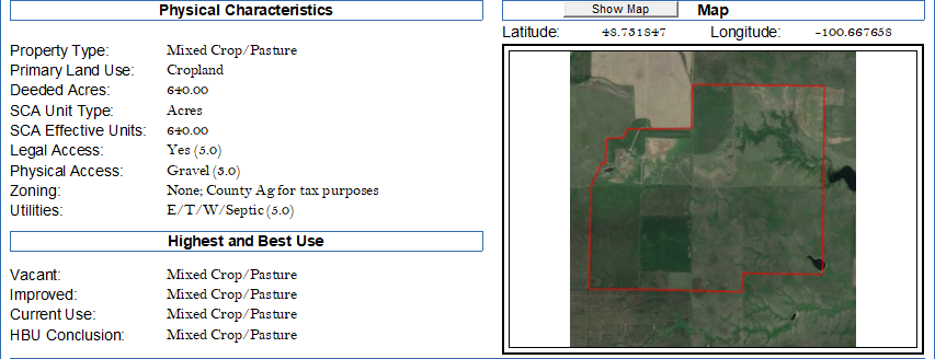
Physical Characteristics (recommended responses):
Property Type: cropland, or pasture. Possibly "mixed crop and pasture", etc.
Primary Land Use: direct to the majority of the subject's value, say cropland. Ranches would likely be pasture, etc.
Deeded Acres: self-explanatory
SCA Unit Type: normally "acres" for the Sales Comparison Approach; however this can be changed to "units", i.e., barrels, bushels, wet-acres (irrigated), "net cropland acres" (only that portion of the property farmed and in production), AUs or AUMs for ranches, etc., to accommodate how differing types of agriculture can be addressed within the same SCA grid.
SCA Effective Units: when acres are NOT used, the number of "effective" units must be entered --- again as barrels, bushels, AUs/AUMs, etc. This number becomes the basis to report $/unit rather than $/acre.
Legal Access: users should not confuse legal versus physical access. Legal access is a simple question, i.e., yes or no. Yes could include interstates, state, county, section-line or formal easements; but, the question is, does the owner of the property have the legal right for access. No means the subject is a "trapped" parcel with no formal legal access.
Physical Access: the question to be answered is, what is the physical access? Answers are usually paved state highway, gravel county road, seasonal gravel, dirt trail, seasonal dirt trail, etc.
Zoning: in most rural areas there is no formal "zoning". If anything, it could be "agricultural" for tax purposes. If zoning formally exists, and brief statement for clarity.
Utilities: responses could range from none to most everything found in rural areas. Abbreviations may be helpful, e.g., E/T/W/Sep. An explanation in the comment section at the bottom of the page would help readers interpret this sequence is for electric, telephone, well, and septic system.
Highest and Best Use recommended responses:
Vacant: "as if" vacant is implied whether or not the subject is vacant. Whatever that use would be, enter the appropriate description.
Improved: enter the improved highest and best use.
Current Use: enter existing or current use (some rule-sets require a statement of current use)
HBU Conclusion: a simple concluding statement for reader clarification
The lower portion of this page contains the valuer's conclusions, allocation(s), and affirmative statement of extraordinary assumptions and hypothetical condition (check-boxes).
Dates: the only manual entry on this page --- if you have not used the Subject QuickStart (SQS) page. If SQS was used, this will be auto-filled. For manual entry, enter the effective date of appraisal (required by USPAP), inspection date, and report date. Report date is the date the final opinion of value is signed.

Approach Summary: this information auto-fills from the approach pages and reconciliation. The second phase of the conclusion is also calculated shown the results as $/acre unless the SCA Unit is NOT acres. Example: if "bushels" are the unit of comparison, the results and conclusion are also shown as $/unit in addition to $/acre. When "acres" are used, the $/unit column will not print or PDF.
Option 2: (Dual Report Summary)
The same recommendations apply for the "dual" summary with the exception of the second reporting option. There are "pick-lists" that delineates between the two reporting options, i.e., "before versus after", or "as is versus as completed", etc. The responses must be shorter because of the dual changes to the same subject property.
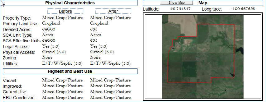
The allocation section is also split to reflect the two situations, each showing the possibility for different conclusions for each.

NOTE: The Report Summary and Reconciliation pages both have calculators (yellow boxes) to show the sum of the incremental allocations add to the value conclusion for each situation.